

Collections of papers relating to specific topics, events, measurement campaings, conferences, symposia or workshops may be published "Special issues". The proposals are welcome. Please use our proposal form (Publication_Proposal_Form.doc).
SPECIAL ISSUES
SEARCHING FOR:
- special issues [disable]
- special issues [disable]
Special issues
Sześć Moich Wypraw Polarnych z IGF PAN w Latach 1975–1991
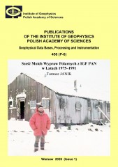
Author(s): Janik T.
Volume: 456
Series: P-6
DOI: 10.25171/InstGeoph_PAS_Publs-2026-001
Volume: 456
Series: P-6
DOI: 10.25171/InstGeoph_PAS_Publs-2026-001
Podczas czterech ekspedycji geodynamicznych do Antarktyki Zachodniej w latach 1979–1991 przeprowadzone były morskie badania sejsmiczne wzdłuż ponad 1000 km szelfu Półwyspu Antarktycznego i Rowu Szetlandów Południowych, od wyspy Elephant do wyspy Adelajdy. Sposób prowadzenia tych badań jest unikalny do dzisiaj, z wielu względów już się nie powtórzy. Zakład Sejsmicznych Badań Litosfery prowadził też badania w Arktyce. W latach 1976–2019 wyruszyło osiem wypraw w rejon Spitsbergenu. Autor opisuje ekspedycję z 1985 roku, jak też wcześniejszą, jeszcze z czasów studenckich (1975), zorganizowaną przez IGF PAN, od której zaczął się jego kontakt z rejonami polarnymi. Wyprawy sejsmiczne dostarczyły bardzo ważnych obserwacji dotyczących północno-zachodniego skraju płyty euroazjatyckiej oraz Grzbietu Śródatlantyckiego na Północnym Atlantyku. Badania przyniosły rozwiązanie szeregu istotnych problemów naukowych, o czym donosiły masowe środki przekazu.
BOOK OF ABSTRACTS. 40th International Polar Symposium – Arctic and Antarctic at the Tipping Point, 4–7 November 2025, Puławy, Poland
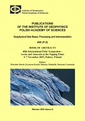
Editor(s): Rurek M., Kozioł K., Moskalik M., Czarnecka M.
Volume: 455
Series: P-5
DOI: 10.25171/InstGeoph_PAS_Publs-2025-067
Volume: 455
Series: P-5
DOI: 10.25171/InstGeoph_PAS_Publs-2025-067
The Polar Symposium is a recurrent conference, typically occurring every two years, dedicated to Arctic and Antarctic topics, with a long tradition dating back to 1972. Since then, these meetings have been an excellent opportunity for integrating the polar community, exchanging experiences, and a discussion between Polish and international polar researchers representing various scientific disciplines. The Polar Symposium is currently co-organised by the Committee of Polar Research, Polish Academy of Sciences, and the Polish Polar Consortium, and until recently it has also been co-organised by the Polar Club of the Polish Geographical Society. Instead, during the 40th International Polar Symposium, a new Polish Polar Club will debut as an independent association, thus continuing the functioning of the Club since 1974.
Atmospheric Electricity: Papers on Thunderstorm and Cloud Electricity
Author(s):
Volume: 442
Series: D-77
DOI: 10.25171/InstGeoph_PAS_Publs-2022-020
Volume: 442
Series: D-77
DOI: 10.25171/InstGeoph_PAS_Publs-2022-020
Problems of thunderstorm and cloud electricity still remain in the mainstream of research of atmospheric physics researchers. Hence, in this special issue of Publications of the Institute of Geophysics, Polish Academy of Sciences, devoted to problems of atmospheric electricity, we present a set of six articles in which we publish some recent results on this subject, obtained by us and our co-workers.
Anisotropy Estimation of Lower Paleozoic Shales from Northern Poland using Microseismic Data
Author(s): Gajek W.
Volume: 432
Series: B-43
DOI: 10.25171/InstGeoph_PAS_Publs-2021-001
Volume: 432
Series: B-43
DOI: 10.25171/InstGeoph_PAS_Publs-2021-001

Downhole microseismic monitoring is a widely used tool for the assessment of hydraulic fracturing job effectiveness. During the process of fluid injection into the reservoir, new fractures develop due to the induced pressure, which gives rise to microseismic events. Therefore, the knowledge of an accurate velocity model is necessary in order to locate the induced micro-seismic events. Subsurface complexity is often raised by a horizontal layering, an intrinsic anisotropy of shales, and aligned fracture sets. That introduces anisotropic effects into the velocity field. In such a case, the anisotropy should be taken into account during the velocity model building. Otherwise, some errors will be introduced into the microseismic event locations, and hence, the interpretation of treatment effects will be biased. Therefore, this thesis is devoted to the anisotropy estimation using downhole microseismic data.
Polish Polar Research: Green-and-White Paper under the aegis of the Polish Polar Consortium (PPC)
Author(s): Lewandowski M., Polkowska Z., Ziaja W., et al .
Volume: 431
Series: P-2
DOI: 10.25171/InstGeoph_PAS_Publs-2020-006
Volume: 431
Series: P-2
DOI: 10.25171/InstGeoph_PAS_Publs-2020-006
The aim of this document is to present the current state of Polish research in the polar areas, as well as to suggest the main directions for further development of this research, taking into account its educational and cognitive importance and its social and economic utility. The book is addressed to the state administration and the scientific communities in Poland, those already engaged in polar studies as well as those seeking new openings in their current research. The book should also be a starting point for updating the current Polar Research Strategy.